Friday, March 18, 2016

TO JOLLY HARBOUR

After a week of twists and turns in English Harbour, we headed west. Up to Old Road Bluff, which is almost the mid-way, water is free of hazards 100 yards away from the shore; however almost after the bluff, a mile square of reefs lie to the south of the island, leaving a narrow channel to navigate through, in order to get to the west shore. It is possible to go from either side of the reefs, but the channel is more protected with calm waters, and south of the scattered reefs is exposed to the east winds and high seas.

Against my character, I insisted that we take the channel, against Al's suggestion to the other route, fearing that his patience might run out while making such a big arc, and run into trouble. After going  into the channel, it became obvious that; first of all it was not very narrow, secondly, the reefs to the south were quite visible, and the rocks on the way to the north were avoidable, and not too far out of the shore. The most amazing part is the varying colours of the water, the shallow parts being a watery turquoise, navigable parts (mostly around 16 - 20 ft) a little deeper, but in no way dark. However, the water was calm, while the outer seas kept on roaring and breaking on the reefs in the distance.

After turning the south west corner, getting to Jolly harbour takes half an hour. The sea in the whole area is very shallow, with some even shallower points here and there. North of Jolly bay, leading to the harbour is protected by a cluster of rocks called Five Islands, and a connected bluff. A smaller mound to the south separates it from a long strip of sparkling white sandy beach, called Jolly beach, a famous destination for the cruise-ship passengers and vacationers. There are a number of resorts / short duration rental homes etc around the area, which drive prices high for the cruisers. The marina at the end of the harbour is popular, the long term storage fees for the boatyard is supposed to be competitive to Grenada and Trinidad. However, everything else is expensive.

We came to the Jolly Bay, and dropped anchor in 8 ft of water, close to the harbour entrance.


According to Doyle, a long and narrow channel was dredged in the middle of the bay to form the entrance to the harbour, which is well marked (intended for boats with deep draft). Of course we don't care.


We will stay here for a week and start our way back to martinique.

Thursday, March 17, 2016

FINALLY ANTIGUA

Al checked the forecast, and suggested to wait another day, to avoid the expected (for that day) 15 to 20 knots of winds, with some gusts. Seas were supposed to be the same either day. I was tired of swerving left and right with the push of the waves when wind was not strong enough to take us through, and thought that 40 odd miles would extend to eight hours or more if we would wait for calm weather. Moreover, the predictions for change usually do not come at the right time, and waiting another day may not help. Since the forecast did not predict dangerous weather, I pushed  ahead as planned.

We raised the sail with one reef, and went under way at 06:10 hours. Clearing the top of Guadaloupe took us about an hour. Doyle warns about very strong wrap around winds, so we were cautious, but since the trade winds had not yet started at that ungodly hour, it was smooth sailing for a while. However, the wind and the seas picked up. Predictions were spot on (for the winds), we saw winds gusting to 25 knots now and then, but the waves were much higher, thankfully the swells were from north east, which hit the boat diagonally from the bow, instead of the side.

Nevertheless, the sail up was rough and tiring, but shorter than expected. We had estimated eight hours, but reached English Harbour, Antigua in less than seven.


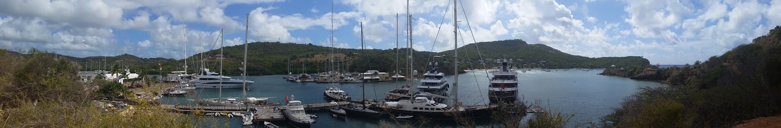
English Harbour is long, extending from south east to north west,  with a small bay to the east of entrance, which turns with a channel that ends with two smaller bays at the end like horns. There are two marinas on either side of the channel, and the inside bays are quite small, which accomodate a handful of boats. The portside marina (Nelson's Dockyard) is full of mega yachts, both motor and sail, and also house the Customs and Immigration office. Right across the channel, there is Slipway boatyard, with a good chandlery and a few spots for docking, but they sell fuel and water to cruisers.

We first thought of exploring the whole harbour before anchoring, but saw that the first anchorage (Freeman's Bay) quite crowded, Al decided to anchor immediately, instead of wasting time, because people usually start coming in the afternoons and jockey for the few spots.

While we were trying to get a good place, the boat in front signalled that they were leaving, so we waited five minutes and anchored in a place safely away from everybody. Doyle cautions about currents and tides in the bay, which require a lot of swinging room around the boats, especially in low winds.


After settling down, we dinghied to the Nelson's marina to clear in. We went straight in and saw some dock space next to a "no dinghy" sign, and got closer. I saw an official looking islander in a uniform, and asked if we could tie there, and he approved, taking the painter from my hand and tying us down. While we were getting out, some guy came along, and told us to get away, shouting something about some row-boats expected to come there in about two hours time. We excused ourselves saying that we just needed to clear in, and promised to come back shortly.

The uniform was watching, and encouraged us to follow him. On the way, he grumbled about "those people bothering everybody", and showed us to the Customs building. He went around the counter, and gave instructions to use the computer where clearing to be done through the "Easy clear" system. Apparently they insisted on using the initial electronic system which was being installed about five years previously in most of the Caribbean, but abandoned since then almost everywhere.

Now many islands use "Sail clear", a different system,  which is very handy, since it can be accessed from one's own computer before reaching the port of destination. Antigua, unlike the others, decided to maintain the old system, and make it usable. It is hard to understand why the others started over, instead of improving an established system. But hey, who can bring so many heads together to agree on something?

During our first night at the anchorage, we heard poeple blowing horns, waving lights and cheering, welcoming the last rower into the harbour. We looked and saw the white row-boat that came in accompanied by a motor-boat.

The next day, we learned that twenty six rowers had participated in the "Atlantic Challenge" sponsored by Talisker Whisky.  That is to say, that those incredibly fit and determined young men have started in Tenerife, Canary Islands and crossed the ocean in about three months, some a little earlier. The first ones were able to reach Antigua at the beginning of February. Why?


Antigua reminded us of Grenada in some ways; people are very friendly and happy, life is easy. It is a small island, with a small population, which seems to be more affluant and better administered. The roads are better, houses well maintained and covered with flowers, mini-buses more comfortable and crime non-existent. Our friend Sid of Liming Time, who came back from Canada for their second season in Antigua, declared that nobody was locking their dinghies, when left at the docks during the day. First time I ever heard such a thing! In Martinique crime reports talk about even gasoline being stolen from dinghies. People regularly take away their starter keys after locking their dinghy chains. Compared to the windward islands, Antigua seems to be the paradise of tranquility. However, prices are higher, water is scarce, landscape is desolate (until the rains came), without much of tall trees. There are more attractions in the water; everywhere except a portion of the southern shore, is covered with reefs, hence snorkelling and diving are popular. There are several  interesting anhorages with clean waters. Sailing around the island is kind of challenging, but not dangerous (like the Tobaggo Keys in the Grenadines), since the problemmatic areas are marked. And flying to Antigua from Canada is easy, with direct flights from Toronto, Ont.

We spent more than a week in Freeman's Bay, and witnessed the boats swinging in circular motions around their anchors, each going a different direction, and at times colliding with each other, if not anchored properly. Wind helps to give direction, and swinging out of order does not happen, but when the wind dies down, nobody knows where one would be. Some bows come together, some sterns.

One time a boat almost hit us while weighing anchor, because its chain had wound around a block of concrete at the bottom (that happened to be there??), and did not come up without unwinding by motoring the boat around it. Our own chain got so twisted that, it was an ordeal to release the snubber hook, because the bridle lines got wound around the chain several times.

One night, we had to ask the boat next to us to anchor somewhere else, since it was swinging dangerously close to us. Everytime we looked up, it was coming towards Ruyam II from a different direction, either by its bow or stern. Poor guy, he was away from his boat for a couple of hours, while we kept watch. When he came back, he saw that his dinghy could not fit between our two boats, and he realized that he had to move, otherwise we would have to stay up the whole night. Anchoring in the dead of night is no picnic, especially in such a tight anchorage, so we felt really sorry for him.

Despite its drawbacks, English Harbour is convenient, because of the amenities in the two marinas, and easy access to the main road with buses to the city (St John). Also it is a picturesque and historical place, which had been in use since the late 1700 s, being a base for Admiral Nelson' s armada in his exploits against Napoleon.


We explored the island on land by taking buses to St John (the city) and to Jolly Harbour at the western coast, and liked what we saw. The city is languidly bustling, which harbours up to four crusise ships at a time. Jolly is another world, developed after the fashion of Florida causeways, with series of townhomes slapped on channels, with a boat slip in front. Apparently these condos are not very expensive to buy (around US$200, 000 as opposed to millions in Florida or any other Caribbean island). Is it worth it? Possibly for people who need a land base for their boats.


Jolly Harbour has a marina and dockyard, which were considered safe during hurricanes (however we could not see any protection around the outlying land, which seemed quite low with some small bumps of  scattered hills.

The topography of Antigua and its the northern twin Barbuda is quite different than any of the other islands in the area. It appears that the two would have been connected if they had been pushed up a little more, since both are sitting on a very shallow shelf (20-30 ft with scattered reefs and solitary rocks in various sizes and shapes) for miles on end. No wonder there were two hundred sunk ships around Antigua, west of which is a shallow basin as far as the eye can see.

Monday, March 7, 2016

PIGEON ISLAND AND BEYOND

Next stop Pigeon Island, a little over two hours motoring from Rivere Sens. The island was Jacques Cousteau' s base for his documentary productions. It is a popular diving and snorkelling destination, and there is a fair sized bay to the east. Last time we had passed through, it was nor very crowded, and I remember having an excellent spot for anchoring. This time there were more boats, and most of the shallow spaces were covered by small craft mooring balls.  Since we came before noon, the boats that stopped just to have lunch made it a bit more crowded than usual. Anyway we found a spot close to two Canadians, and enjoyed the clean water and the sun. Our anchor and chain started to get cleaned. The water at the west coast of Guadalupe is amazing!

Third morning, we headed towards Deshaies at the North west corner, about an hour from Pigeon Island. Our timing was perfect (around 10:00 am when we reached there), we saw several boats leaving, which encouraged us, looking at the numer of masts. While getting ready to anchor, we saw that two mooring balls were available. Since we were to start early the next morning, taking a ball was ideal. A couple of hours later, we watched people dropping in, and frantically searching for a place to anchor.

It is not a bad anchorage, but the small town around it is pathetic - restaurants, dive companies and nick-nack shops for tourists. The only bakery was closed that day, but the post office instant teller was working, thank God. We spent some time on land, and came back on board to get ready for the long passage.

TAKING FUEL

If one ventures to get fuel from Rivere Sens one should be ready to jump down from the boat (not too hard since there is no wind), find a bollard to tie (harder, since there are only two, one at the dead corner of the dock, where a big fishing boat was tied almost next to the fuel dock. The other bollard was at the opposite end but inside corner.)  Morevover, get ready for abuse from the attendants, who do not speak a work of English themselves, and think that all English speakers are idiots. If you can past the hurdles, diesel is the cheapest in the Caribbean; 1.00 Euro a litre.

Since our helm is on the port side and Al wanted to see what I would be doing, he turned around and approached the dock from the port side. Our cleat  for the back tie is almost halfway down the side, which would not give enough space to clear the stationed boat, if I used it, so I pushed the line through the dingy cleat at the stern to tie the boat, to keep the back flush with the dock.

After securing the boat, Al went up to inform the attendant. He came back, and went through the motions as instructed:
(1) Release the nozzle of the left side of the left pump (located at the pier, three or four steps above the dock)
(2) Take the nozzle of the corresponding long hose coiled around the drum on the actual dock
(3) Press on the nozzle to fill your tank.

When Al pressed the handle nothing came out.  Al remarked that the pump was not working. So he went up again, came back with a Frenchman (some customer trying to help). Two of them prodded here and there, looked at the other coil of hose, but everything seemed to be in order. The good Samaritan went back up, and still nothing happened. After Al's third request, the attendant could not help but come all the way down, throwing up his arms,  rolling his eyes, and shouting " le gauch, le gauch, mon Dieu".  Well we know, we got the one at "le gauch", but there was no power. Poor Al was saying "n'est pa electricite", to no awail. But after seeing that it was not our fault, he went back up and dealt with the start up at his computer. At last it worked for the port tank.

When Al took the nozzle to the starboard tank the same story, no go. I told Al that the pump counter had not cleared, hence not allowing a second usage. Another trip up and down, finally we filled the tanks, which took us more than an hour (ten minutes tops in any other fuel dock).
Ridiculous!

RIVIERE SENS - ONE WORD TO SUM IT UP: RIDICULOUS

There is a small anchorage at the mouth of the little hole-in-the-wall bay, which is completely occupied by the Riviere Sens Marina. In order to clear the vessel into Guadaloupe on the west coast, everybody has to stop there and use the computer of one of the restaurants located in the marina.

There were two boats moored, and one big boat on anchor close to the entrance of the marina when we came. We turned around the small indentation of a beach, which was quite deep until very close to the shore, while the wind was blowing from West - Northwest. Al was reluctant to go too far into the beach in that kind of winds, so we anchored about 20 ft of water, not too far from one of the moored boats. Before we anchored, I tried to connect to the marina to see if we could get a berth for one night, to replenish our fuel and water. There was no response from the marina, so we had to venture anchoring in deeper and too-close-for-comfort conditions.

We left Ruyam II a little after the noon hour, in a hurry to clear in, and dingied to the marina  from the narrow channel. I spotted the fuel dock on the right side of the channel, right before the marina docks started, which were full to capacity. There was a seasoned French couple in a dingy in front of us so we thought we should follow them to the dingy dock. They went up to the launching pad at the far corner of the channel, and the lady got her oar in hand, getting close to the ramp. We shouted at them about a dock to tie, and she said "this is it". Whaat?

All the docks were connected to each other by bridges, so there seemed no way of getting into the marina. We went to the east wall (made of big boulders, sloping out) and came up to the bridge, which had a locked gate at the end. There were some guys loitering around the gate, so we asked if there was a dock for us. The young guy got hold of my painter, and pulled the dingy (hard) over the boulders, and tied it to the gate frame. He said "you're good to go". Again, whaat?  We used the boulders to step on to get to the dock.

Four years ago we had passed through this place, while the marina was being built (by a Canadian company no less). We had been helped the same way out of our dingy by an islander at that time over the same boulders, although the bridges and docks were not in place. Later on, we had gone by dingy to the north wall of the marina, where a nice dock had been installed in front of the strip of restaurants.

This time, since we had been tied already, we thought to get to the north side on foot, and deal with the clearing in, instead of bothering with the dingy into the unknown. On the way, we passed by the Capitainerie, and tried to speak with the dock master about water/fuel. The glass door was locked, and the inside deserted. It looked like a posh hotel entrance, very clean and airy.  No wonder, nobody seems to use it!

We found the restaurant which clearly advertised itself as the customs clearence site, however the lady attendant  said in her broken English "impossible". We must have shown despair, since she reluctantly smiled, and showed a small sign, denoting the customs clearing time; only between 15:00 and 18:00 hours. Al almost started an argument, but I interjected and assured her that we could come back. Apparently, she had only one computer, which she did not wish to be meddled with. She was the one entering the information, so needed the noon rush at the restaurant to be over.
She had "reason" in her mind, understandable.

We had about two hours to kill, so we thought of dropping in the fuel dock to see if we could get fuel early next morning, before starting north. We then realized that the ridiculous fuel dock could be used for tying the dingy, but the space behind it was too close to the boulders at various depths of its wall. Scary, but we had to tie the dingy there, and walk up ten steps and some distance to the actual fuel station at the top to find a body. There was an islander attendant at the office, who informed us that they would be open at 6:30 am and would allow us to get fuel, but it was self serve. So we had to tie the boat ourselves, get the attendant turn on the fuel pumps, and do the actual filling ourselves.

Can be done. In the meantime, we asked if they were also selling camper butane bottles, since we had finished one of ours, but had not been able to fill it in St Anne. Al is always nervous if we do not have at least two spare at the boat. Anyway, the attendant said he only had two left, so we should hurry to get it. We rushed back to Ruyam II, got the empty bottle, rushed back, and grabbed it. Al was happy, at least one thing accomplished, and we had killed almost an hour. Win-win.

After putting the bottle safely in the boat, we dingied back to the marina, this time using the western most channel leading up to the north wall, and found a spot to tie on the dock, which was almost covered by big boats tied stern-to. Tying the dingy was one thing, getting out of it onto the dock was another.  The new dock was built much higher this time, to accomodate big boats. Nobody cares about outsiders with dingies; maybe it is a safety issue.

We had half an hour to sit at the veranda overlooking our dingy, and have some refreshments. We had earned it running around like crazy. The lady got our clearance paper from Martinique, and some more information, and filled the thing herself. That was good. The best part of French islands is the ease with which clearing in and out can be accomplished. As a matter of fact it can be done at the same time, as long as you know which day you are leaving.

Al further asked her what was up with the marina office, and she said something in French (which we did not understand) and after deliberation she remarked that  they were "lazy". Okey, makes sense. VHF does not work, maybe the "capitain de port" has cell phones, and open up the shop when needed. All those boats must have come to the marina at some point in time, although most of them seemed to be long term residents.

ON THE WAY TO ANTIGUA

After staying in St Anne, Martinique for almost two months, we thought moving a little would do us good. Everybody was raving about Antigua, which we had skipped while coming down from BVI four years ago.  Antigua is almost accross the sea to the North east of Montserrat, which we had favoured at that time (and for good reason, it was amazing!).

Anyway, we decided to spend the month of March around Antigua, taking our time going up and down, after which, it would be closing the season in and around Grenada. It is incredible how fast this year is going.

As always we watched the weather, which had been very stormy and wet for the last two months (where is the dry season?), but the weather started to calm down for about a week starting on the 27th of February, so we weighed anchor that day from St Anne at 7:00 am towards St Pierre, the North west corner of Martinique.

Selecting a mild weather to sail is contra-intuitive one can say, which forces one to turn on the engines to beat the waves. Even on the first portion of the way going directly west to the Diamond rock, the wind was not strong enough to push us through, despite having sails wing-on-wing. However, we reached our destination
around noon, thanks to our Volvo s.

The passage to Dominica was likewise light on the winds, but with high seas, which again compelled us to use the engines some of the way. Boo!

There was not much change in Rousseau, Dominica, except that Pancho is no more. According to SeaCat (the Greg and Beanie duo), maintaining mooring balls required one to dive, and Pancho was more into land affairs than swimming lately. We had a nice chat with Beanie instead.

Portsmouth (anchorage at the North west of Dominica) was likewise unchanged, but we detected fewer boat-boys, but more professional service from  PAYS (the co-operative that maintain and protect the mooring balls). Cobra is likewise seemed to be into bigger things (good for him).

Passage to Guadaloupe was also luck-lustre and tedious with mild wind/high seas. When we reached Rivere Sens, at the  South west corner of Guadaloupe, we were quite tired from the constant beating of the waves from 90 degrees.